
Overview
The UC Emergency Management (EM) Geographic Information System (GIS) Systemwide Facility Data Layer Automation project team won the Silver Yvonne Tevis UC Collaboration Award at the 2025 UC Tech Awards. This project provides UC EM and Business Continuity (BC) staff with access to a trusted UC systemwide facility dataset they can use to map UC facilities and their proximity to emerging hazards/threats.
The project team designed and implemented an automated workflow that collects and unifies facility data from every UC location into a single data product. It produces the most accurate and complete dataset of UC facilities, updates monthly, and is accessible in a systemwide GIS platform with built-in tools for overlaying potential threats/hazards.
The Challenge
As emergencies happen, EM staff across the UC system are responsible for quickly assessing how the incident may impact the UC’s people, facilities, and property. This situational awareness is critical to all aspects of emergency response. In 2020, the systemwide UC EM Council formed a GIS subcommittee to explore how GIS could better support incident situational awareness. The subcommittee quickly identified a significant gap: the UC did not have a single geocoded source layer of all its facilities. To resolve this, a small project team was formed and undertook the painstaking process of creating a single automated GIS data layer containing the precise location of all UC facilities. The resulting layer, containing over 7,000 facilities, is the most comprehensive, accurate geospatial layer currently available in the UC.
The Approach
Data Sharing
Each UC location independently maintains the most current list of its owned and leased facilities. Securing access to these locally maintained facility datasets was the most critical and foundational component to building an accurate and complete systemwide facility GIS layer. To do this, the project team identified 23 common fields and two common data formats (flat file and GIS file) and then coordinated with locations to establish formal Data Sharing Memoranda of Understanding (MOUs) that describe how and when each UC location would provide the facility data needed for this project.
To accommodate the need for two data formats, a logic workflow was developed to help process each location’s facility data. The workflow is designed to ensure a geolocation for each facility is assigned accurately and that other facility attributes are successfully merged from the local datasets into the systemwide layer. This workflow is applied to each UC location’s dataset then a final merge of each UC location’s datasets is performed to create a single GIS data layer of all UC facilities.
Environment and Software
The workflow process is performed on a UCSF Research Analysis Environment (RAE) virtual machine which provides elevated data security. Esri’s ArcGIS Pro desktop application and Python libraries are installed to enable the workflow process to run and to perform the GIS tasks. UC locations with available GIS data share this data at ArcGIS Representational State Transfer (REST) web services, which maintain a persistent link in the UC Office of the President ArcGIS Online instance. When the process workflow is run, it connects to the UC Office of the President ArcGIS Online instance and reads the web service data, then performs its tasks locally.
Once per month, UC locations submit their flat file to a Box folder in RAE. Nearly all locations submitting flat files have automated this task. The workflow process reads the flat file and GIS data for each location and performs a comparison. Ultimately a final merge task is performed, appending all the active records into a single GIS layer of facility points and footprints. The new version is published to UC Office of the President’s ArcGIS Online instance every month, where it becomes available for viewing and analysis.
Development & Go Live
UC Santa Cruz’ Center for Integrated Spatial Research (CISR) developed and wrote Python code for a process to sync, automate, and maintain the single GIS layers (one point layer, one footprint polygon layer) of UC facilities from 17 source files. Due to field mapping and to standardize values, a specific process had to be developed for each UC location to successfully update the production GIS layer. The workflow went live in July 2024 and has successfully run monthly since then.
The Impact
Completion of this first-of-its-kind project in the UC system has transformed the use of GIS for EM situational awareness.
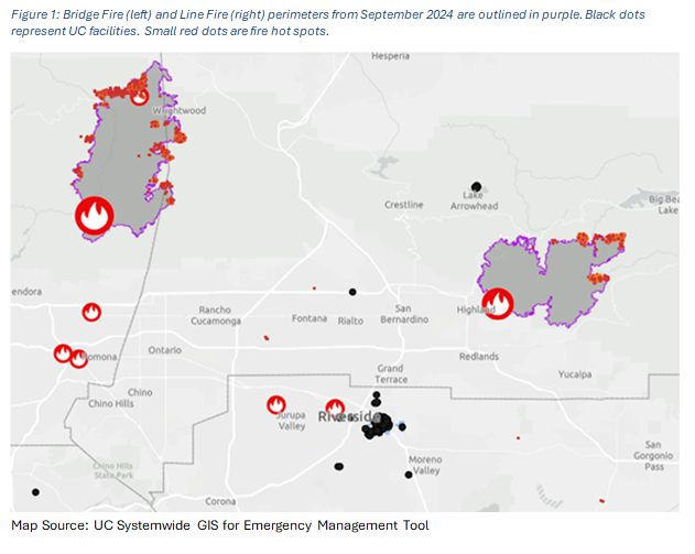
- So far, the impacts are particularly impactful for evaluating threats from wildfires.
- UC Office of the President Systemwide EM routinely use the resultant GIS product to identify, analyze, and display the proximity of UC’s facilities to emergent wildfires throughout the wildfire season. Figure 1 provides an example.
- EMs at UC locations also use the GIS tools made available from this project for wildfire monitoring, including UCLA’s use during the January 2025 Los Angeles wildfires to enhance situational awareness.
- All UC EM and BC staff can access and use the GIS for EM tool.
Why It Matters
By enhancing situational awareness of threats to UC facilities and the people who occupy them, the project strengthens UC’s ability to continue teaching, research, public service, and patient care when disruptions occur.
What’s Next
Members of the project team are currently exploring additional applications of the unified facility data for integrations related to seismic safety, land use, and continuity of operations.
Meet the Award-Winning Team
Team Name: UC Emergency Management GIS Systemwide Facility Data Layer Automation
Award Category: Yvonne Tevis UC Collaboration Award
Locations:
- All UC campuses
- All UC Health locations
- Division of Agricultural and Natural Resources (ANR)
- Natural Reserve System (NRS)
- Office of the President (UC Office of the President)
2025 Silver UC Collaboration Award Winners:
| Name | Title | Department | UC Location | Affiliation |
| Amina Assefa | Director, Emergency Management & Business Continuity | Risk Services | UC Office of the President | Staff |
| Alicia Jensen | Program Manager, Emergency Management & Business Continuity | Risk Services | UC Office of the President | Staff |
| Barry Nickel | Director, Center for Integrated Spatial Research | Department of Environmental Studies | UC Santa Cruz | Staff |
| Mono Simeone | GIS Manager | Real Estate | UCSF | Staff |
*Team membership as of the date of project completion (July 2024). Other project team members not listed are:
- Charles Schafer (former Emergency Management Coordinator at UC Davis Health)
- Aaron Cole (Senior GIS Analyst for UC Santa Cruz Center for Integrated Spatial Research at the time of his death in August 2023)
Read More
Read the team’s complete UC Tech Awards application
Learn more about the UC Tech Awards Program
Contact

Program Manager, Emergency Management & Business Continuity Office of Risk Services
UC Office of the President
[Cover image of Laurel Skurko, accepting the award on behalf of the team with CIOs Matthew Gunkel, Aisha Jackson and Molly Greek, is courtesy of Andrew Castro]